Select NOAA-NWS Forecast Office Text Products

(Product availability varies with seasons, forecast office, and weather.)

Hazardous Weather Outlook for State College, PA

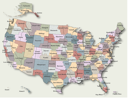
To Select Another NWS Office Click on Map or Choose from List

County Warning Area MAP
Select Forecast Office:   Select Product:  
629
FLUS41 KCTP 100822
HWOCTP

Hazardous Weather Outlook
National Weather Service State College PA
322 AM EST Wed Dec 10 2025

PAZ004>006-010-011-110830-
Warren-McKean-Potter-Elk-Cameron-
322 AM EST Wed Dec 10 2025

...WINTER WEATHER ADVISORY NOW IN EFFECT UNTIL 4 AM EST FRIDAY...

This Hazardous Weather Outlook is for central Pennsylvania.

.DAY ONE...Today and tonight.

Please listen to NOAA Weather Radio or go to
weather.gov/StateCollege on the internet for more
information about the following hazards.

   Winter Weather Advisory.

.DAYS TWO THROUGH SEVEN...Thursday through Tuesday.

Please listen to NOAA Weather Radio or go to
weather.gov/StateCollege on the internet for more
information about the following hazards.

   Winter Weather Advisory.

In addition, wind gusts up to 45 mph from the west or northwest are
likely Thursday.

.SPOTTER INFORMATION STATEMENT...

Spotters are encouraged to report significant hazardous weather.

$$

PAZ017-110830-
Clearfield-
322 AM EST Wed Dec 10 2025

...WINTER WEATHER ADVISORY NOW IN EFFECT UNTIL 4 AM EST FRIDAY...

This Hazardous Weather Outlook is for central Pennsylvania.

.DAY ONE...Today and tonight.

Please listen to NOAA Weather Radio or go to
weather.gov/StateCollege on the internet for more
information about the following hazards.

   Winter Weather Advisory.

.DAYS TWO THROUGH SEVEN...Thursday through Tuesday.

Please listen to NOAA Weather Radio or go to
weather.gov/StateCollege on the internet for more
information about the following hazards.

   Winter Weather Advisory.

In addition, wind gusts up to 45 mph from the west or northwest are
likely Thursday.

.SPOTTER INFORMATION STATEMENT...

Spotters are encouraged to report significant hazardous weather.

$$

PAZ012-018-110830-
Northern Clinton-Northern Centre-
322 AM EST Wed Dec 10 2025

...WINTER WEATHER ADVISORY REMAINS IN EFFECT UNTIL 10 PM EST THIS
EVENING...

This Hazardous Weather Outlook is for central Pennsylvania.

.DAY ONE...Today and tonight.

Please listen to NOAA Weather Radio or go to
weather.gov/StateCollege on the internet for more
information about the following hazards.

   Winter Weather Advisory.

.DAYS TWO THROUGH SEVEN...Thursday through Tuesday.

Windy and colder. Narrow, meandering bands of snow showers and
localized squalls will bring an additional coating to 1 inch of snow
and potentially hazardous travel conditions in briefly poor
visibility and snow covered roads. Wind gusts up to 45 mph from the
west or northwest are likely Thursday.

.SPOTTER INFORMATION STATEMENT...

Spotters are encouraged to report significant hazardous weather.

$$

PAZ037-041-042-110830-
Tioga-Northern Lycoming-Sullivan-
322 AM EST Wed Dec 10 2025

...WINTER WEATHER ADVISORY REMAINS IN EFFECT UNTIL 10 PM EST THIS
EVENING...

This Hazardous Weather Outlook is for central Pennsylvania.

.DAY ONE...Today and tonight.

Please listen to NOAA Weather Radio or go to
weather.gov/StateCollege on the internet for more
information about the following hazards.

   Winter Weather Advisory.

.DAYS TWO THROUGH SEVEN...Thursday through Tuesday.

Windy and colder. Narrow, meandering bands of snow showers and
localized squalls will bring an additional coating to 2 inches of
snow and potentially hazardous travel conditions in briefly poor
visibility and snow covered roads. Wind gusts up to 45 mph from the
west or northwest are likely Thursday.

.SPOTTER INFORMATION STATEMENT...

Spotters are encouraged to report significant hazardous weather.

$$

PAZ024-033-110830-
Cambria-Somerset-
322 AM EST Wed Dec 10 2025

...WINTER WEATHER ADVISORY REMAINS IN EFFECT FROM 10 AM THIS MORNING
TO 10 AM EST THURSDAY...

This Hazardous Weather Outlook is for central Pennsylvania.

.DAY ONE...Today and tonight.

Please listen to NOAA Weather Radio or go to
weather.gov/StateCollege on the internet for more
information about the following hazards.

   Winter Weather Advisory.

.DAYS TWO THROUGH SEVEN...Thursday through Tuesday.

Please listen to NOAA Weather Radio or go to
weather.gov/StateCollege on the internet for more
information about the following hazards.

   Winter Weather Advisory.

In addition, wind gusts up to 45 mph from the west or northwest are
likely Thursday.

.SPOTTER INFORMATION STATEMENT...

Spotters are encouraged to report significant hazardous weather.

$$

PAZ019-025>028-034-045-046-049>053-110830-
Southern Centre-Blair-Huntingdon-Mifflin-Juniata-Bedford-
Southern Clinton-Southern Lycoming-Union-Snyder-Montour-
Northumberland-Columbia-
322 AM EST Wed Dec 10 2025

This Hazardous Weather Outlook is for central Pennsylvania.

.DAY ONE...Today and tonight.

A few periods of wet snow today could accumulate up to 1 inch and
result in slippery roads. Wet surfaces and slush will refreeze
tonight and may result in slick spots on untreated roads and
sidewalks into Thursday morning.

.DAYS TWO THROUGH SEVEN...Thursday through Tuesday.

Windy and colder. Narrow, meandering bands of snow showers and
localized squalls will bring an additional coating to 1 inch of snow
and potentially hazardous travel conditions in briefly poor
visibility and snow covered roads. Wind gusts up to 45 mph from the
west or northwest are likely Thursday.

.SPOTTER INFORMATION STATEMENT...

Spotters are encouraged to report significant hazardous weather.

$$

PAZ035-036-056>059-063-110830-
Fulton-Franklin-Perry-Dauphin-Schuylkill-Lebanon-Cumberland-
322 AM EST Wed Dec 10 2025

This Hazardous Weather Outlook is for central Pennsylvania.

.DAY ONE...Today and tonight.

A brief period of freezing rain or sleet could mix with wet snow
early today before changing to rain intermittent light rain for the
late morning and afternoon hours. Locally hazardous travel
conditions are possible especially on bridges and overpasses.

.DAYS TWO THROUGH SEVEN...Thursday through Tuesday.

Westerly wind gusts of 35 to 40 mph are likely Thursday. Otherwise, the
probability for widespread hazardous weather is low.

.SPOTTER INFORMATION STATEMENT...

Spotters are encouraged to report significant hazardous weather.

$$

PAZ064>066-110830-
Adams-York-Lancaster-
322 AM EST Wed Dec 10 2025

This Hazardous Weather Outlook is for central Pennsylvania.

.DAY ONE...Today and tonight.

The probability for widespread hazardous weather is low.

.DAYS TWO THROUGH SEVEN...Thursday through Tuesday.

Westerly wind gusts of 35 to 40 mph are likely Thursday. Otherwise, the
probability for widespread hazardous weather is low.

.SPOTTER INFORMATION STATEMENT...

Spotters are encouraged to report significant hazardous weather.

$$

Lambert

Previous Hazardous Weather Outlooks may be found at
NWS State College, PA (CTP) Office Hazardous Weather Outlooks.
(Click 'Previous Version' there to view past versions successively.
Some may differ only in time posted.)

San Juan, PRHonolulu, HI Lake Charles, LA Pueblo, CO Corpus Christi, TX St. Louis, MO Reno, NV Raleigh, NC  Newport/Morehead City, NC Dodge City, KS Houston/Galveston, TX San Joaquin Valley/Hanford, CA Louisville, KY Fort Worth, TX Pittsburgh, PA Austin/San Antonio, TX Sacramento, CA Jackson, MS Phoenix, AZ Northern Indiana, IN Flagstaff, AZ Tallahassee, FL Springfield, MO Riverton, WY Blacksburg, VA Sioux Falls, SD El Paso Area, NM Columbia, SC Wilmington, NC Greenville-Spartanburg, SC Eureka, CA Midland/Odessa, TX Tucson, AZ Goodland, KS Huntsville, AL Amarillo, TX Norman, OK Lubbock, TX Marquette, MI Little Rock, AR Pendleton, OR Missoula, MT Binghamton, NY Boston, MA Green Bay, WI Billings, MT Baltimore/Washington San Diego, CA Tampa Bay, FL Morristown, TN Twin Cities, MN Brownsville, TX Portland, OR Des Moines, IA Memphis, TN Pocatello, ID San Angelo, TX Jacksonville, FL Aberdeen, SD Quad Cities, IA/IL Charleston, SC New Orleans/Baton Rouge, LA Peachtree City, GA Shreveport, LA Grand Rapids, MI Medford, OR Albany, NY Wichita, KS Gray/Portland, ME Spokane, WA Boise, ID Denver/Boulder, CO Great Falls, MT Caribou, ME Key West, FL Miami-South Florida, FL New York City/Upton, NY Melbourne, FL Hastings, NE Paducah, KY Glasgow, MT Bismarck, ND Charleston WV Omaha/Valley, NE Buffalo, NY Jackson, KY Kansas City/Pleasant Hill, MO Gaylord, MI Cheyenne, WY Grand Forks, ND Detroit/Pontiac, MI Central Illinois, IL Burlington, VT Salt Lake City, UT Topeka, KS Nashville, TN Milwaukee/Sullivan, WI Albuquerque, NM Las Vegas, NV Wakefield, VA La Crosse, WI Birmingham, AL Los Angeles/Oxnard, CA Chicago, IL Seattle, WA Rapid City, SD Indianapolis, IN Philadelphia/Mount Holly, PA Mobile/Pensacola State College, PA Cleveland, OH Elko, NV Wilmington, OH Grand Junction, CO North Platte, NE Tulsa, OK San Francisco/Monterey Bay Area, CA Duluth, MN Anchorage, AK Fairbanks, AK Juneau, AK Tiyan, GU

Products Courtesy of NOAA-NWS
NWS Information Parsing Script by Ken True at Saratoga Weather - WFO and Products Scripts by SE Lincoln Weather.
Mapping by Curly at Michiana Weather and by Tom at My Mishawaka Weather.